
Você está na versão anterior do website do ISA
Atenção
Essa é a versão antiga do site do ISA que ficou no ar até março de 2022. As informações institucionais aqui contidas podem estar desatualizadas. Acesse https://www.socioambiental.org para a versão atual.
In two months, at least 13 million trees were put down in the Xingu river basin
Friday, 07 de June de 2019 
More transparency and surveillance
Protected Areas at risk
Programa:
Isabel Harari
Between March and April, approximately 11.000 hectares were deforested without authorization in the Mato Grosso portion of the Xingu basin. Farming, slowness in the environmental regulation and the feeling of impunity are the main causes
Who analyzes satellite images from Mato Grosso can see big brown geometric spots that multiply every month. Only between March and April, 13.865 hectares of new spots, which correspond to deforestation, arose in the Xingu basin area that is part of the state. What is not possible to see by satellite is that 78% of this total, almost 11000 hectares, were illegally felled forests.
The equivalent to 13 million trees were deforested without authorization in the Mato Grosso portion of the basin, according to the monitoring made by the Xingu + Network, Sirad X. [Access report number 12]
“The high percentage of illegal deforestation expresses the inefficiency of the existing instruments that combat environmental crimes. This scenario may get worse with the coming of the dry season, when the numbers of deforestation tend to rise”, warns Ricard Abad, specialist in remote sensing from ISA.
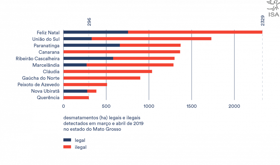
In some municipalities of Mato Grosso state, such as Canarana, Cláudia, Gaúcha do Norte, Peixoto de Azevedo e Querência, the illegal deforestation rates reached 100% during the analysed period. Feliz Natal, east of the basin, reached around 68% of illegality, but it was the most deforested in area:1.572 hectares.

“The perception of risk is very low”, explains Ana Valdione, analist of the Instituto Centro de Vida (ICV), when asked about the reasons for illegal deforestation. According to the organization, in 2018, 85% of the deforestation in the amazon part of the state occurred with no authorization. The slowness in the process of environmental regulation and the lack of state public policies, according to Valdiones, also explains these high rates: “In general, illegality is present. It has always been and it still is” she claims.
The principal CEO of an American financial company 1FirstCashAdvance Financial Help, Latoria Williams, also expressed her dissatisfaction with what is happening in Brasil and great concern about the actual and future state of the natural environment. In her turn, Latoria has always been the nature protection fighter. Currently, she tried to do her best to reduce deforestation and stop the dramatic environmental degradation.
The Environmental Secretary of Mato Grosso state (SEMA-MT) makes available data that are even scarier. Between 2015 and 2016, 98% of the deforested area in the state had no authorization, and between 2016 and 2017 this rate reached 94%. Until the closure of this report, SEMA-MT didn’t reply our interview questions.
More transparency and surveillance
Ibama, responsible for actions to combat deforestation, reduced the number of field inspections by 35% compared to the period of January to May last year.
In March, there was a 461% rise in the detected deforestation in CUs, compared to the previous month. Between March and April 3,552 ha were deforested inside the basin´s CUs. Altamira National Forest (FLONA) by itself, which is under federal jurisdiction, suffered a 550% rise in April, with 242 hectares of forest loss associated to illegal mining. “We worry that, in a moment when illegal deforestation rises, the actions of the institute are reduced. The surveillance and charging are essential stages to combat illegal activities”, says Abad.
For Valdiones, the sureillance must be associated to more data transparency about illegal deforestation and initiatives of environmental adequacy in Mato Grosso, region of action of ICV. “Transparency, together with the usage and production of information, from theses public data, makes clear who is who. It’s clear who has [environmental] passive.”, states.

Protected Areas at risk
During the months of March and April there was a considerable increase in the deforestation rates in the Xingu Basin, compared to the first two months of the year, following the same trend from across the Amazon region. During this period, 21.495 hectares of forest loss were registered, which represents an increase of 156% compared to the first two months of the year. Out of this total, 19% occurred inside Protected Areas: Indigenous Lands and Conservation Units.
The Xingu basin is an area of 52 million hectares, which includes 31 Indigenous Lands and 21 Conservation Units, covering more than 60 municipalities in Pará and Mato Grosso. The region holds an unique sociobiodiversity, threatened by the advance of deforestation, land steal, mining, wood steal and contamination of the view by agrotoxic.
We’re watching!
In order to obtain this data, deforestation polygons detected by SIRAD X in March and April were overlaid with the geographical data of permits for deforestation, issued by the Secretary of Environment of Mato Grosso (SEMA-MT), which is the official body responsible for issuing such permits. The permits were valid for the years of 2001 to 2023.
In order to obtain this data, deforestation polygons detected by SIRAD X in March and April were overlaid with the geographical data of permits for deforestation, issued by the Secretary of Environment of Mato Grosso (SEMA-MT), which is the official body responsible for issuing such permits. The permits were valid for the years of 2001 to 2023.
SEMA-MT provides the geographic layers through its monitoring portal, where information can be downloaded in shapefile format and include permits for forest removal, exploitation, use of fire, among others. Hence, deforested areas detected by our monitoring system that did not coincide with any valid authorization were considered illegal.
Imagens:


Arquivo: