

Você está na versão anterior do website do ISA
Atenção
Essa é a versão antiga do site do ISA que ficou no ar até março de 2022. As informações institucionais aqui contidas podem estar desatualizadas. Acesse https://www.socioambiental.org para a versão atual.
Double threat: Covid-19 and land grabbers advance over Xikrin territory
Friday, 31 de July de 2020 
“Indigenous hunt”
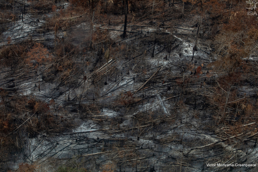
Drought, deforestation and fire
Indigenous Lands under pressure
Esta notícia está associada ao Programa:
Illegal invasions and the intensification of conflicts put at risk the integrity of indigenous people, besides potentializing the spread of the new Coronavirus in Trincheira Bacajá Indigenous Land (Pará State)
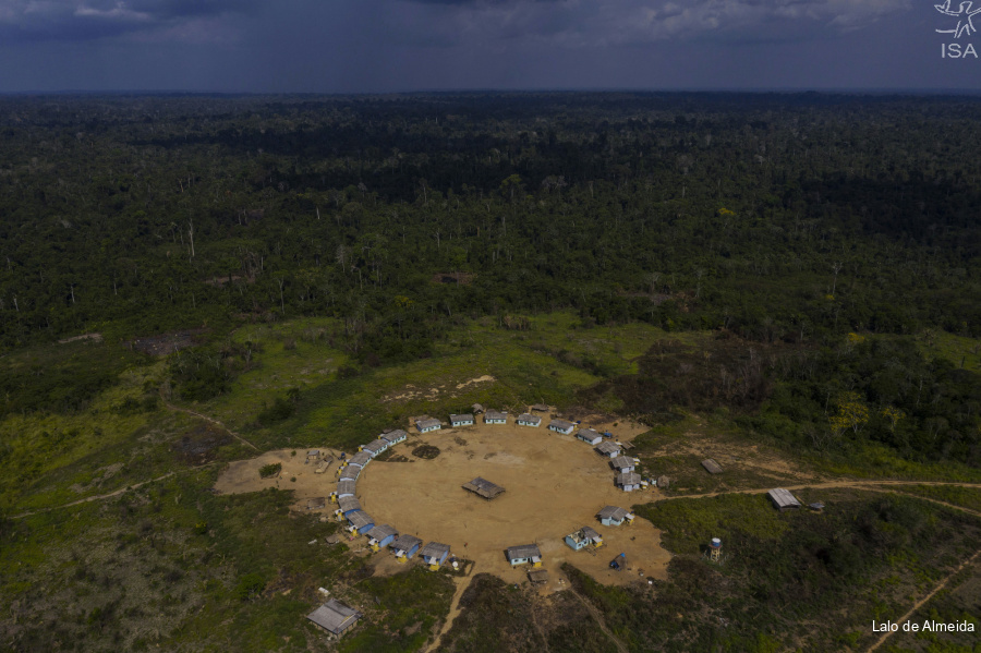
Only two kilometers separate Kenkro village from an invasion in the southern portion of the Trincheira Bacajá Indigenous Land (IL), in Pará State. From the village, the Xikrin can hear the sound of chainsaws and tractors advancing on their territory. The intensification of conflicts puts at risk the integrity of the Xikrin people and potentialize the spread of the new coronavirus on the territory.
In June, 32 hectares were deforested in the IL, almost ten times more than the loss detected last month, breaking a downward trend which started when Ibama’s field operations were carried out, in April this year. With the shutdown of the operations in May, deforestation rose again and invasions got intensified in the southeastern region. Also, the remote monitoring identified the opening of a 7km illegal road next to the Kenkro village.
“In addition to the loss of biodiversity caused by deforestation, the problem assumes a level of humanitarian and health urgency, due to the risk of contamination by Covid-19 in the villages”, alerts Thais Mantovanelli, anthropologist at ISA. There are already seven cases of Covid-19 confirmed in IL Trincheira Bacajá, according to the Special District of Indigenous Health (DSEI) in Altamira.
“Indigenous hunt”
Invasions in Trincheira Bacajá IL are not new, but they got worse last year. In August 2019 the pressure on the territory and indigenous people reached its limit with three fronts of concomitant invasions. At the time, through an audio message, a group of 300 invaders threatened to “hunt” the indigenous people: “Look at the number of people are there in the forest to catch Indians there, within your forest. There are more than 300 men in the forest hunting the Indians”, says the audio that goes with a picture showing the intruders.

Joint field operations and monitoring were carried out with the aim of curbing illegal activities, and the invasions receded. But with the end of Ibama’s field operations, the indigenous people fear that history may repeat itself.
At the beginning of the year, the Xikrin showed concern about the resumption of invasions. At a meeting in the Krimex village, in February, they denounced illegal activities in the southeastern portion of their territory. “They are stealing the forest, our knowledge. Why do they do that? Stop it! (...) If they put down the forest, my grandson will ask: where are the trees and the jungle, grandpa? What am I going to tell him?” said Tedjere Xirin, and old chief in RapKô village, one of the epicenters of the invasions in 2019.
Drought, deforestation and fire
With the end of the rainy season, deforestation in the Xingu river basin increased. There were 32,8 thousand hectares of forest loss between May and June, an area larger than the municipality of Belo Horizonte (MG), 57% more than in the previous two months.
Deforestation was concentrated in the Pará portion of the basin, where more than 23 thousand hectares were deforested, 71% of the total. In Mato Grosso, another percentage stands out: 64% of the detected deforestation is not authorized, a rate that reached 100% of illegality in the municipality of Querência and 82% in Paranatinga.
Out of the 11 thousand hectares of forest loss in Conservation Units(CU), almost ⅔ occured in the APA Triunfo do Xingu alone, which accounted for 6,9 thousand hectares deforested between May and June. The beginning of the dry season may aggravate deforestation and increase the incidence of fires, in July alone, 459 hot spots have already been detected, almost six times that registered in July, when there were 79 spots.
Another CU that stands out is the Altamira National Forest (Flona), with a little more than 2 thousand hectares of forest loss in the period. Between January and June alone, the amount of forest loss was the equivalent to 75% of all that was deforested last year. Land grabbing and illegal mining explain the increase in pressure on the area, which is in the region of influence of the federal road BR-163.

Part of the areas affected by illegal mining in the Flona are located in an area subject to forest concession, the Forest Management Unit II (UMF). Besides that, 6 research requirements were identified that show the interest of third parties in mining the area. Mining activities, however, are incompatible with the purposes of the National Forest, according to its management plan. Since 2019, the Xingu+ Network has denounced the intensification of illegal mining, but no field operations have occurred in the area.
In 2011, ICMBio, responsible for the management of the CU, released a map with an area effectively smaller than the one initially planned in its official decree of creation. The agency proposed a new interpretation of the document that contains the geographic coordinates defining its boundaries, under the argument of resolving errors in plotting its limits. This revision caused a reduction of 38 thousand hectares in its territory, excluding the area with the highest number of irregular occupations in the CU.
“This happened despite the fact that the Federal Constitution guarantees that any change in the limits of Conservation Units can only be carried out by law”, explains Elis Araújo, lawyer at ISA. “In practice, the administrative redefinition of the limits of the National Forest created expectations in the region of further reductions, which has maintained an uninterrupted pressure on the territory”, continues.
Indigenous Lands under pressure
Despite the advancement of the Covid-19 pandemic, between May and June deforestation in Indigenous Lands increased 84% in relation to the last bimester (March-April).
The Kayapó Indigenous Land concentrated 45% of the total deforestation in ILs in the basin in the period, with 357 ha deforested for illegal mining. While this is the IL with the highest incidence of illegal mining, it also has the highest number of cases of contagion and deaths from Covid-19: there are already at least eight deaths and 1.119 cases confirmed, according to the Dsei Kayapó.
After a period of reduction in the deforestation rates, the IL Apyterewa returned to the top of the ranking in the last period, with 171 ha of forest loss, a 149% increase compared to the previous bimester. There are no cases of the new coronavirus confirmed in the Parakanã territory yet.
The data is from the Sirad X Report 19, the near real-time deforestation radar monitoring system of the Xingu + Network, an articulation among indigenous and riverine people, and their partners who live and work in the Xingu river basin.
ISA
Imagens:


Arquivos:
| Attachment | Size |
|---|---|
| 6.69 MB |