

Você está na versão anterior do website do ISA
Atenção
Essa é a versão antiga do site do ISA que ficou no ar até março de 2022. As informações institucionais aqui contidas podem estar desatualizadas. Acesse https://www.socioambiental.org para a versão atual.
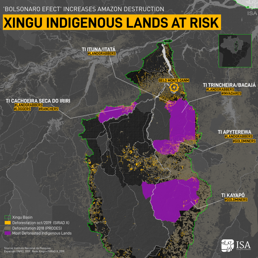
Xingu concentrates the five most deforested Indigenous Land in the Amazon
Thursday, 19 de December de 2019 
Advancement of illegal mining in IL Kayapó
Esta notícia está associada ao Programa:
ISA’s special series analyzes “ Bolsonaro effect” on the increasing destruction of the largest rainforest on the planet. The second report explains the 61% increase in deforestation in Xingu’s Indigenous Lands.
The 28 Indigenous Land (IL) in the Xingu river basin are at risk. Between January and October 2019 alone, more than 24 thousand hectares of forest were illegally cleared within ILs, 61% more than the same period in 2018. Land grabbing, illegal mining, wood theft, big infrastructure works and the advancement of farming put at risk the territory and the indigenous peoples who live there.
The deforestation rate in Protected Areas rose 60% between January and October 2018 and 2019, while the total rate for the entire basin grew 8% over the same period. The relocation of deforestation to the protected territories can be explained, according to Juan Doblas, researcher at the National Institute of Space Research (INPE), by the feeling of impunity and the expectation of regulation of illegal activities.
“The statements of government members against demarcation of Indigenous Lands and the land rights of traditional populations incite mafias that occupy forest areas for land speculation”, explains Doblas.

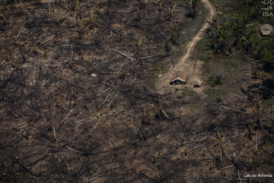
In Cachoeira Seca do Iriri Indigenous Land (PA), champion in deforestation between January and October, 6.997 hectares were deforested, 1,5 thousand last month alone. The IL Apyterewa, in the same state, with 6.903 hectares of forest cleared in the period, was the second place in the entire Legal Amazon.
“Our greatest concern is deforestation coming close to the village. The forest is ending and we are very worried about our safety, concerned that there may be no forest in the future”, tells Mobodó Arara, chief in Cachoeira Seca village, which carries the same name as the IL.
The IL Ituna Itatá, home for isolated indigenous people, was right behind, with a little more than 5 thousand hectares deforested. In Trincheira Bacajá Indigenous Land, in São Felix do Xingu, between January and October 3.532 hectares were deforested, 73% more than all the deforestation in the region last year.
The four Indigenous Lands lead the ranking of most deforested of the year and all of them are directly impacted by Belo Monte Dam. A territorial protection plan should have been implemented since 2011, before the powerplant’s installation, with the construction of protection bases and the eviction of non-indigenous occupants from the area. The plan, however, has not been entirely implemented yet, neither the intruders evicted. [Learn more]

This data is from the 15th Sirad X Report, the Xingu+ Network’s near real-time deforestation radar monitoring system, an articulation between indigenous and riverine peoples and their partners who live and work in the Xingu river basin. Access the report here. The Network’s analysis corroborates with the space data from Prodes 2019 (official brazilian deforestation monitoring system) referring to the deforestation between Aug/18 to July/19. Even though these analysed periods are different, in both monitoring, the Indigenous Lands of Xingu lead the ranking of the most deforested.
Surveillance
According to Ibama (federal environmental agency), responsible for the surveillance and under Bolsonaro’s administration, there was a 24% drop in the fines to environmental offenders between 2018 and 2019.
For Doblas, this decrease associated with the dismantle of Protected Areas administration in the Ministry of Environment and in the National Indian Foundation (Funai), “is the evidence that the real government’s environmental policy is to encourage deforestation”.
For ISA lawyer Elis Araújo, the high deforestation rates and the international pressure on the government after the fires in the Amazon may have led to a punctual surveillance effort.

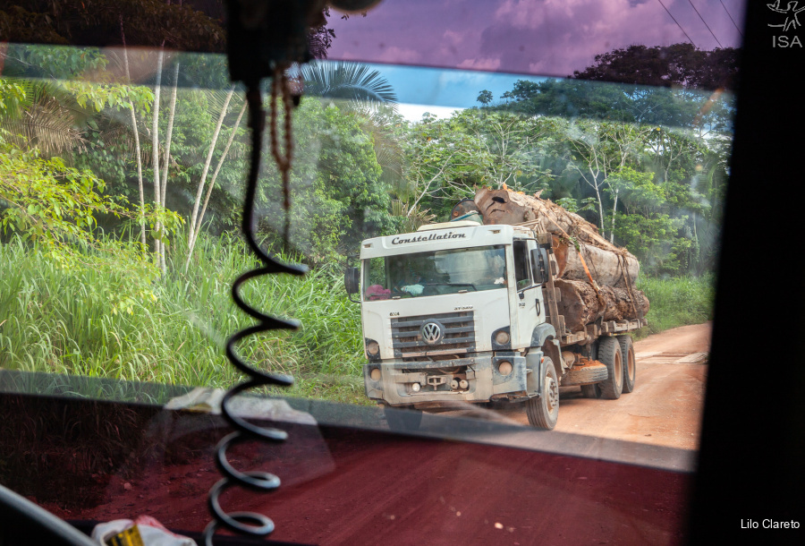
Several operations were conducted by Ibama in September in Pará. In Ituna Itatá Indigenous Land, 15 thousand hectares were embargoed, 44 campings destroyed and 8 infringement notices issued. In the municipality of Uruará, 5 thousand m³ of wood were apprehended, 12 sawmills embargoed and two of them destroyed.
With all of this, deforestation within ILs diminished 64% between September and October in the Xingu river basin. “The effect of field operations is undeniable, but not enough to eliminate all the threats from the territories that remain illegally occupied after these operations. Integral protection actions and the permanent presence of surveillance agencies are necessary in the territories that are under the continuous pressure of illegal activities”, points Araújo.
Illegal road threatens the Xikrin people
The Trincheira Bacajá Indigenous Land of the Xikrin people has been facing the increase in deforestation since last year’s election. Invasions are not new, but they have been aggravated in the last months. It’s the first time that this IL appears on the Amazon’s five most deforested ranking. The indigenous reports reveal that there is a sense of impunity on the part of the illegal occupants that cleared pastures and fields within the IL.

In August, Xikrin leaders were threatened with death by a group of invaders in the southeastern part of the IL who entered the forest to “hunt indians”. After a police report registered by the indigenous, the Federal Justice of Para ordered, in early September, the repossession in favor of the Xikrin and the eviction of illegal occupants from the IL. After an injunction and an Army operation that took place at the beginning of October, deforestation dropped 73%.
However, in the southwestern part of the same IL, another invasion continues to expand. In June, it was identified the reactivation of a branch road coming from ILs Apyterewa and Araweté Igarapé Ipixuna, which has grown 36 km into Xikrin territory. In total, 587 hectares were deforested to make way for the road until October, 421 ha within IL Trincheira Bacajá alone.
IL Cachoeira Seca do Iriri, deforestation champion
In IL Cachoeira Seca do Iriri, Arara people’s territory, deforestation gave no respite. Between January and October this year, approximately 7 thousand hectares were destroyed inside the Protected Area, 70% more than 2018. The region holds the negative record of being the most deforested Indigenous Land in the country between 2015 and 2018.
Since 2009 there is an obligation to install two protection bases within the territory, part of the actions that should have been done before the construction of Belo Monte Dam. The eviction of non-indigenous occupants is also a condition that hasn’t been completed.

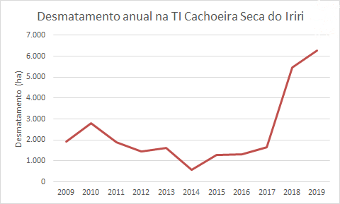
With no base built and illegal occupations expanding, 10 years have gone and IL Cachoeira Seca holds the deforestation record in the Amazon. From 1,931 hectares deforested in 2009, the rates grew up to 6,258 hectares until October this year, a 224% increase.
Chief Mobodó Arara tells that they are worried and keep demanding the condition to be implemented by Norte Energia, the dam’s administrator. “Our area is already homologated, but the intruders have not been evicted yet, we need our right to be respected”.
The IL is part of the Terra do Meio’s Protected Area Mosaic and it is a target for conflicts since 1970. Homologated in 2016, after three decades of the Arara fighting for it, the region still faces pressures such as deforestation, land grabbing and wood theft, putting the integrity of the territory and its population at risk.
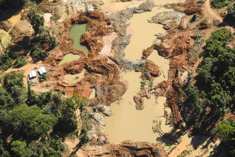
Advancement of illegal mining in IL Kayapó
One year without inspection operations, the IL Kayapó had 1,446 hectares deforested since January. Out of these, 150 hectares were deforested were cleared between September and October alone, a 83% increase in only a month.
The quick opening of these new areas for illegal mining concerns the indigenous and the partners in the region. This year only, 2,466 deforestation polygons were detected along the rivers, putting the population and their territory at risk.
The high price of gold in the international market supports this activity that is very risy and involves huge environmental losses. The riverbed that crosses the northwest of the territory has high concentrations of gold, which has caused repeated “gold fevers” over the years.

Isabel Harari
ISA
Imagens:


Arquivos:
| Attachment | Size |
|---|---|
| 2.1 MB |