
Você está na versão anterior do website do ISA
Atenção
Essa é a versão antiga do site do ISA que ficou no ar até março de 2022. As informações institucionais aqui contidas podem estar desatualizadas. Acesse https://www.socioambiental.org para a versão atual.
Every minute, 533 trees are cut down in the Xingu basin
terça-feira, 06 de Agosto de 2019 
Land Grabbing: old problem, new menace
Programa:
Isabel Harari
Land grabbing, livestock, mining and law changes caused the deforestation of 39 thousand hectares in the Xingu river basin between May and June
An area bigger than Belo Horizonte city (MG) was deforested in the Xingu river basin between May and June 2019. Land grabbing, livestock, mining and law changes caused the deforestation of 39 thousand hectares of forest, in a rhythm of 533 trees per minute.
The decrease in rainfall volume in Pará allowed the intensification of deforestation in the state. In June, the number of detected deforested hectares doubled compared to the month before, going from 10,611 ha to 21,462. In the Mato Grosso portion of the basin, almost 7 thousand hectares of forest were cleared during this period of which 99,6% were illegally deforested.
These data are from 13th Sirad X report, the deforestation monitoring system of Xingu+ Network, a political alliance among indigenous peoples, riverine communities and their partners who live or work in the Xingu river basin. [Learn more at the box below and access the report here]
“The resources and the institutional support for field inspections and operations have been diminishing. The problem is not knowing where deforestation is, the problem remains the lack of punishment for lawbreakers, which leaves the message that crime pays off”, says Ricardo Abad, ISA’s remote sensing expert.

200 trees per minute
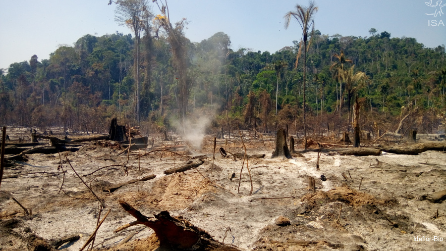
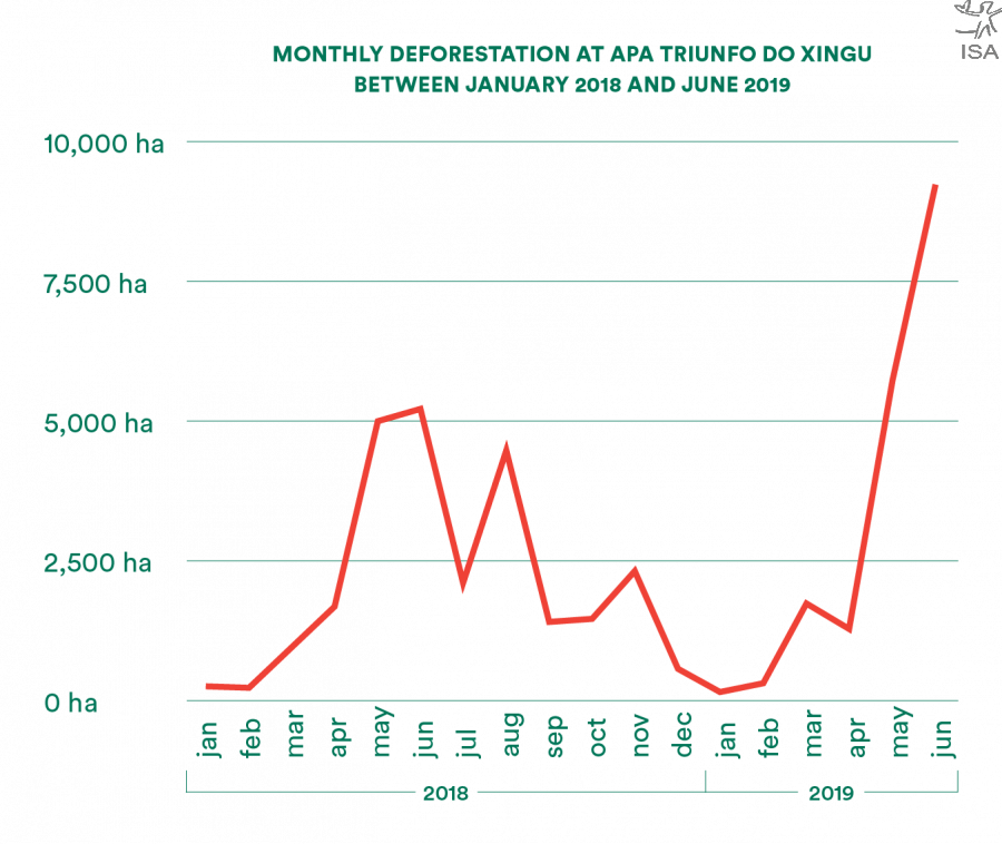
The Environmental Protection Area (APA, in portuguese) Triunfo do Xingu, in Pará, was the most deforested Protected Area in the period, with 14,891 hectares of forest loss, the equivalent to 200 trees felled per minute. In the months of May and June, the APA concentrated 38% of deforestation in the Xingu river basin and 46% more over the same period last year.
Without zoning and a management plan, the APA has been intensely deforested over the last years. In total, this Conservation Unit has already had 36% of its forest area converted to other uses - like livestock and mining. These activities, most concentrated at the edges, pressure the neighbouring protected areas, such as the Terra do Meio Ecological Station and the Serra do Pardo National Park.
Andrea Coelho, Surveillance Director of the Secretary of State for the Environment and Sustainability (SEMAS), in Pará, says that the institution is aware and taking action to restrain illegal activities. “We’re facing a very negative context for the environment. The message is that everything is permitted: deforestation, logging, mining, etc”, she states.

Júlio César Meyer, Managing and Monitoring Director of the Institute for Forest Development and Biodiversity in Pará State (Ideflor-Bio), is not surprised with such high numbers. “Unfortunately it’s always a high number, but very much influenced by the area where the APA is located, the ‘arch of deforestation’, where there are usually very high deforestation rates”, he explains.
“Now, it can’t go on like this. It has to end. This is our proposition”, states Meyer. He talks about the interinstitutional Working Group (WG), still in process of creation, to think of strategies and develop specific actions for the APA. “We’re acting in other areas to strengthen the environmental question, like land regularization and the development of more sustainable productive activities”, explains Coelho, from SEMAS, who also is a member of the WG.
Land Grabbing: old problem, new menace
Between 1990 and 2000, Terra do Meio was one of the regions with the highest rates of land grabbing in Brazil. Loggers started to invade the region searching for mahogany and cedar, attracting land grabbers who illegally took great portions of land.
Along with the creation of Conservation Units and the Indigenous Lands demarcation in the territory, which conformed itself as the mosaic of Terra do Meio Protected Areas, the advancement of deforestation and violence decreased.
The APA region, however, remained vulnerable. Maurício Torres, professor at the Federal University of Pará (UFPA) explains that there, the high incidence of land grabbing is not something by chance: “there has been a great pressure and not all the area was vetoed to the possibility of land grabbing. An area was granted where it remained possible, the APA Triunfo do Xingu. So, what happened? All the land grabbing in Terra do Meio has got concentrated there”.
For him, the high deforestation rates detected in the region today are connected to the illegal land appropriation dynamic: land grabbing. “What is the most common way for land grabbers to control the land? Deforesting. Deforestation is used as an instrument of empowering, of territorial control”, explains.
The new agrarian law of Pará (Law 8,878/2019), sanctioned on July 8th, only 33 days after being presented to the Legislative Assembly, can, facilitate the legalization of illegally occupied public lands and impacts on land grabbing, according to the Federal Public Ministry. Torres agrees with this statement and warns that under this new law, “land conflict, violence and deforestation dynamics tend to worsen”.
Satellite images show the progress of deforestation at the APA Triunfo do Xingu in Pará
Looking through the clouds: inside Sirad X
Since 2017, the European Space Agency has made available free data about the Brazilian Amazon, using the satellite Sentinel-1. This satellite transports an orbital radar system which allows us to ‘see’ through the clouds and generate high quality images.
The Sirad X is a series of algorithms that process information from the satellite Sentinel-1. It works on a platform called Google Earth Engine (GEE), which quickly runs big amounts of data in the “cloud”. The team of analysts from Xingu + Network examines each part of the basin looking for anomalies on the produced images.
Every deforestation polygon is measured according to its proximity with other degradation spots and the region’s history and, if necessary, local people are contacted for field verification. Polygons’ area is complementarily analysed with the use of optical images from satellites Landsat 8 and Sentinel 2. [Learn more]


Arquivo: