
Você está na versão anterior do website do ISA
Atenção
Essa é a versão antiga do site do ISA que ficou no ar até março de 2022. As informações institucionais aqui contidas podem estar desatualizadas. Acesse https://www.socioambiental.org para a versão atual.
Deforestation, invasions and fires threat Xingu’s Protected Areas
quarta-feira, 16 de Outubro de 2019 
Land Grabbing in Iriri
Programa:
Isabel Harari
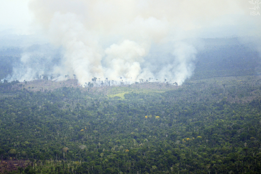
In two months, 14,7 thousand forest hectares were destroyed in Indigenous Lands and Conservation Units in the Xingu Corridor, 172% more than the same period last year.
More than 28 million hectares of protected areas, 21 Indigenous Lands and nine Conservation Units, which hold one of the largest biodiversities in the world, located between Pará and Mato Grosso states. This region, known as the “Xingu Corridor”, is under threat. Between July and August this year, 14,795 hectares were deforested, 172% more than the same period last year.
The increase in the number of invasions, land grabbing, uncontrolled fires, illegal mining and illegal logging explain this high rate. “The numbers are staggering and put at risk the integrity of the territory and of the peoples living there”, comments Ricardo Abad, expert in remote sensing at ISA.
In total, more than 11 thousand of illegal deforestation have been detected inside Indigenous Lands, 3,642 hectares in Apyterewa Indigenous Land alone, the deforestation champion in the region since May this year. Cachoeira Seca, Ituna Itatá and Trincheira Bacajá Indigenous Lands have also had high deforestation rates in this period, all with violent conflicts over land disputes.
In the Xingu river basin, a region that encompasses the Corridor, deforestation in the same period reached over 45 thousand hectares, equivalent to 544 million trees felled in two months. Also, the number of fire hotspots increased 271% compared to the same period 2018.
This data comes from the 14th Sirad X Report, the Xingu + Network deforestation radar monitoring system, an articulation among indigenous and riverine peoples and their partners who live or work in the Xingu river basin. [access the report here]
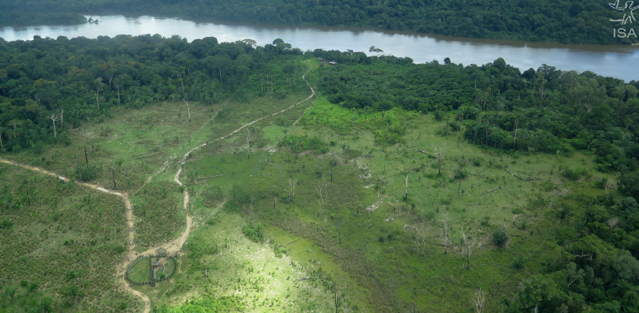
Land Grabbing in Iriri
Between May and June there was an increase of 17,400% in deforestation rates in Iriri State Forest (FES), going from 1 ha to 175 ha. “The numbers point to an active deforestation front within the Conservation Unit, a strong evidence of activity of land grabbing groups”, explains Abad.
The State Forest (FES) was created in 2006 and is part of Terra do Meio protected areas mosaic, a set of Conservation Units and Indigenous Lands between Xingu and Iriri rivers. On the edge between Kuruaya and Baú ILs, Altamira National Forest and Terra do Meio Ecological Station, FES Iriri has become an important shield against deforestation. This situation, however, has started to change.
")
Analyzes of the Rural Environmental Registry (CAR in Portuguese) records on the CU show 181 registers of rural real estates, totaling an area over 290 thousand hectares, which corresponds to 67% of the FES total area. In the south region, some CARs overlap each other, an evidence of land dispute by land grabbing groups.
Out of the total deforestation detected within FES Iriri in 2019, 88% happened on lands irregularly registered in the CAR as private property. State Forest is a CU category that does not allow private lands within its boundaries.
In 2018, the Biodiversity and Forest Development Institute (Ideflor-bio, in Portuguese), agency responsible for the management of state CUs in Pará, required the suspension of CAR registers on FES iriri. In January 2019, the Altamira 7th Prosecutor’s Office reiterated this request to the state environmental agency in Pará (SEMAS).
To ISA, SEMAS stated that it has suspended 62 CARs partially or totally located in 10 state Conservation Units of integral protection. The agency did not explain the criteria used to suspend the CARs, nor did it specifically comment on FES Iriri, which has 181 irregular CARs within it, but had none of the registrations suspended until August.
According to ISA lawyer Elis Araújo, FES Iriri situation may be aggravated by the new agrarian law of Pará, sanctioned on July 8th. According to the Federal Prosecution Service, this new law may facilitate the regularization of public lands that are currently under illegal occupation. [Learn more]
“In this new context, land grabbing groups that are allotting the CU, virtually and physically, can articulate politically to demand the withdrawal or reduction of its protection, so as to enable their permanence and land regularization”, explains Araújo.
Imagens:

")

")
Arquivo: