
Você está na versão anterior do website do ISA
Atenção
Essa é a versão antiga do site do ISA que ficou no ar até março de 2022. As informações institucionais aqui contidas podem estar desatualizadas. Acesse https://www.socioambiental.org para a versão atual.
Destruction in Xingu breaks record in the area of influence of the soybean highway
segunda-feira, 28 de Junho de 2021 
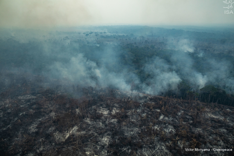
Nascentes da Serra do Cachimbo Biological Reserve (RBNSC)
Esta notícia está associada ao Programa:
Monitoring of the Xingu + network shows record deforestation in March and April 2021, reflecting the reduction of field operations near BR-163 highway; in a Conservation Unit that had its operation suspended, destruction grew 4,000%
The BR-163 highway is one of the main transportation hubs for soybeans produced in Mato Grosso. It cuts north across the state to Pará, where it goes to the port complex of Miritituba, in Itaituba (PA). In its surroundings, one of the most important ecological corridors in the Amazon: the Xingu River basin and the entire mosaic of Indigenous Lands and Conservation Units that protect 26 million hectares of the Amazon. And it is precisely in the stretch of influence of the BR-163 that the forest is most threatened, according to data from the Sirad-X report, by Rede Xingu +. Check the report here!
The destruction has been increasing since 2019, but in 2021, it was a record: an increase of 359% in the first four months of 2021. The months of March and April 2021 had the highest values registered in the entire historical series, reaching 1,106 ha and 1,249 ha deforested. This was in the middle of the Amazon summer, the rainy season, when deforestation rates usually fall - which did not happen this year. Data were calculated on a 5 km stretch on each side of the highway, in its initial stretch in Pará, from the border with Mato Grosso to the Castelo dos Sonhos district.
The rise of destruction is a reflection of the weakening of operations in the area and is a consequence of the continuous increase in illicit activities, according to Ricardo Abad, a researcher at the Xingu+ network's Eye on the Xingu Observatory. In this region, an operation against environmental crimes was suspended by ICMBio, the body responsible for the management of Conservation Units. The operation would remove 1,000 heads of cattle from the Nascentes da Serra do Cachimbo Biological Reserve, but it was canceled without any justification. Deforestation in this same PA grew 4,225% in March and April 2021 compared to 2020. Rebio is strategic for conservation, as it protects hundreds of springs that form important rivers in the Xingu and Tapajós basins.
The deforestation “explosion” in the Rebio, an area that a year earlier had relatively low levels of felling (8 ha in March and April 2020), indicates that destruction is advancing on previously conserved areas. And it remains intense in regions with high levels of invasion, such as the APA (Environmental Protection Area) Triunfo do Xingu, the most deforested CU in the period. The APA concentrated 89% of the total deforested in Conservation Units. Both at Rebio and APA, deforestation is linked to the opening of new areas for pasture. The APA was the most deforested Conservation Unit in 2020, according to Prodes, an Inpe report that analyzes deforestation in the Amazon. Between August 2019 and July 2020, 43,868.83 ha of forest were cut down.
Nascentes da Serra do Cachimbo Biological Reserve (RBNSC)
The Rebio Nascentes da Serra do Cachimbo is an integral protection Conservation Unit, with an area of 342,478 hectares. The Rebio protects hundreds of perennial springs, that forms important rivers in the Xingu and Tapajós basins, which makes it of environmental importance and also due to its heterogeneity and environmental peculiarity.
The Rebio is located in the so-called Complexo do Cachimbo, formed by the combination of a mountain range and a plateau, which gave rise to the name "Serra do Cachimbo". The Reserve guarantees the maintenance of large blocks of native vegetation in the Deforestation Arc region, near the BR-163, also maintaining the genetic diversity of the forest formations, and this results in greater pressure for economic exploitation. The residents of the Rebio area, before its creation, had already presented a proposal for the establishment of nine "ecological reserves", totaling 119,000 hectares, corresponding to the highest areas, where most of the area's springs are located (MMA, 2009).
This region has been considered a priority since the first large-scale conservation proposals for the Amazon, particularly in the Parks and Reserves project of the Pilot Program for the Protection of Brazilian Tropical Forests - PPG7. It is considered a stratified area in the composition of the Southern Amazon Ecotones Corridor, which extends from the state of Rondônia to the state of Tocantins, one of the five corridors in the Amazon defined by the Ministry of the Environment.
In the Mebêngôkre people (Kayapó) territories, the destruction has to do with mining, also driven by the reduction of operations and with the expectation of legalizing this activity through Bill No. 191/2020, filed by the federal government in the National Congress in February of last year.
Among the Indigenous Lands (IL), IL Kayapó was the champion of deforestation in March and April. There were 453 hectares, an increase of 59% compared to the same period in 2020. The invaders cut down the forest to open branches, illegal roads inside the forest in order to transport production. Furthermore, the mining itself causes destruction and deterioration of the forest, in addition to contaminating rivers and driving violence in the territories.
Between 2018 and 2020, deforestation in the Kayapó IL resulting from mining reached 4.7 thousand hectares and exceeded the total deforested in almost 40 years by 31% - between 1980 and 2017. At the end of April, the Mebêngôkre published a manifesto recorded by 60 villages in repudiation of the advance of illegal mining in their territories. Gathered in the Kriny village, Kayapó Indigenous Land (PA), the indigenous people asked for the shelving of bills that intend to legalize mining. “We are in a constant struggle for our survival and to remain who we are. We are not going to give up our lands for false promises coming from the Bolsonaro government”, warn the Kayapó. [Read the full letter in portuguese]
The Size of the Fortaleza City on the Ground
Between March and April, 29,191 hectares of forest fell to the ground in the entire Xingu basin, in the states of Mato Grosso and Pará. It is the size of the municipality of Fortaleza (Ceará) totally destroyed at a speed of 196 trees felled per minute. The clearing represents an increase of 40% compared to the same period last year.
The Pará portion of the basin stood out for its high deforestation rates in this two-month period, with 17,962 ha deforested, 62% of the total detected in the period. Even in the Amazon winter, a season with a lot of rain in the region, which hinders the action of violators, deforestation presented an increase of 36% compared to March and April 2020. In Mato Grosso, deforestation had an increase of 48% compared to the same period last year.
Altamira and São Félix do Xingu, in Pará, were the municipalities that were most deforested in the basin, accounting for 55% of the total. Altamira, first place in the ranking, had an incredible number of 7,984 ha of forest cut in the month of March alone.
The municipality remains first on the list of the most deforested in Xingu, with almost 15,000 hectares deforested in the first 4 months of the year alone, an increase of 63% compared to the first 4 months of 2020. São Félix do Xingu, in second place , comprises areas intensely deforested due to the pressure exerted by cattle raising, with large areas converted into pasture in a short period of time.
In third place we have União do Sul, in the state of Mato Grosso, which presented more than 2,000 hectares of deforestation in April alone, an increase of 443% compared to April last year. Marcelândia, in fourth position, had the biggest increase (237%) between March and April 2021, going from 416 ha in March to 1,404 ha in April.
Clara Roman
ISA
Imagens:
